9.22.11. Terrain Elevation Difference
This element is of enormous use for comparing the heights between two simultaneously drawn terrains. Immediately afterward the dialog box is displayed, and the characteristics are given.
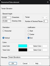
Element height: Represents the immediately preceding numerical data’s distance to the element. This value can be expressed in two different ways:
· In number of characters.
· In Drawing Units.
When validating either of these, the other value will automatically recalculate.
Number of Decimal Places Number of decimal places that will be displayed in the values representing the cut/fill.
Direction: Establishes the text direction. There are two possibilities - Horizontal and Vertical.
Justification: Establishes the text position in respect to the point of insertion. There are three possibilities: Start, Centre and End.
Terrain 1/ 2: We select the terrains between which a height comparison will be made. Previously, in the Draw Longitudinal window, in the option Terrain, the profiles we wish to compare should have been included. The order in which the profiles have been selected is the order in which they appear in the dropdown menu.
Colors: Possibility to customize the color of the horizontal line and the texts associated with the element that is represented.
Message: Text that will appear as the element’s title on the numerical data drawing.