1.9. Project Window |
The project window allows you to have an overview of the files generated by MDT in the course of a job. The files are grouped by categories, according to the type of information they contain. Both the categories and the files they contain have context menus that appear when you click on them with the right mouse button, and allow you to execute MDT commands.
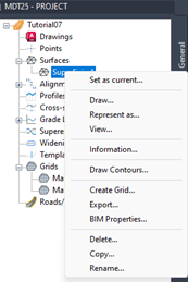
Project Window with Surfaces category menu
By default, all categories are displayed. Clicking on Roads/Segments or Surfaces makes it possible for only files from one of these two categories to appear in the list. Making active General will display all the files again.
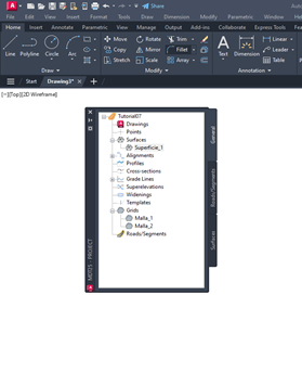
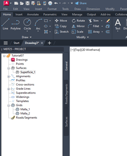
The project is a floating CAD window so that the user can move it or place it in any location in the work area, as if it were just another window in the software.
In the following two images you can see how the project window is configured as a floating window within the drawing area, and how to place it as if it were another information panel.
 |
 |
A description has been provided below of each of the categories as well as of the operations or commands that can be executed at each of them.
For each of the files associated with each category there will be three common operations:
1. Delete: Eliminates the file from the project and, optionally, from the computer.
2. Copy: This allows the carrying out of a file duplicate.
3. Rename: Tool for changing the file name.
4. Add Files: This allows us to add the specified file to the project.
Each of the categories and files related to the project have their own associated commands which are listed below and are described in detail in their respective sections.
For each of the surfaces, alignments and road segment files included in the project, there is the possibility of adding or consulting their BIM properties, in case you have one assigned.
Points: Points files associated with the project.
Associated operations:
|
Category
|
Action
|
|
Import
|
Import
|
|
Export
|
Check
|
|
List
|
|
Surfaces: Surfaces files associated with the project.
Associated operations:
|
Category
|
Action
|
|
Create Surface
|
Set as Current
|
|
Import
|
Draw
|
|
|
Represent As
|
|
|
View
|
|
|
Information
|
|
|
Draw contours
|
|
|
Create grid
|
|
|
Export
|
|
|
BIM Properties
|
Alignments: Horizontal alignment files associated with the project.
Associated operations:
|
Category
|
Files
|
|
Convert Polyline
|
Edit
|
|
Alignment Input
|
Check
|
|
Import
|
Draw
|
|
Draw Alignments
|
Dimension
|
|
Dimension Alignments
|
Locate
|
|
Delete Dimensioning
|
List
|
|
|
List by interval
|
|
|
Convert
|
|
|
Get Longitudinal Profile
|
|
|
Get Cross Sections
|
|
|
Generate Widenings
|
|
|
Generate Superelevations
|
|
|
BIM Properties
|
Profiles: Longitudinal profile files associated with the project.
Associated operations:
|
Category
|
Files
|
|
Get Profile
|
List
|
|
Get Profile by Regression
|
Check
|
|
Profile Input
|
Draw Simple Profile
|
|
Convert Drawing Profile
|
Update
|
|
Convert from 3D Polyline
|
|
|
Import
|
|
|
Get multiple Profiles
|
|
Cross sections: Cross sections files associated with the project.
Associated operations:
|
Category
|
Files
|
|
Obtain Profile
|
List
|
|
Import
|
Check
|
|
Obtain multiple Profiles
|
Draw
|
|
|
Update
|
Grade Lines: Grade line files associated with the project.
Associated operations:
|
Category
|
Files
|
|
Convert Grade line from Polyline
|
List
|
|
Define Grade Line
|
Check
|
|
Import
|
Draw Compound Profile
|
Superelevations: Superelevation files associated with the project.
Associated operations:
|
Category
|
Files
|
|
Generate Superelevation
|
List
|
|
|
Check
|
Widenings: Widenings files associated with the project.
Associated operations:
|
Category
|
Files
|
|
Generate Widenings
|
List
|
|
|
Draw
|
Templates: Templates files associated with the project.
Associated operations:
|
Category
|
Files
|
|
|
Edit
|
Grids : Grid files associated with the project.
Associated operations:
|
Category
|
Files
|
|
Create Grid from Surface
|
Draw
|
|
Read Drawing Mesh
|
Draw Heights Map
|
|
Import
|
|
Road Segments : Segment files associated with the project.
Associated operations:
|
Category
|
Files
|
|
New Segment
|
Define/Edit
|
|
|
List Profile
|
|
|
Draw Compound Profile
|
|
|
Draw Cross sections
|
|
|
Generate Modified Terrain
|
|
|
Get Modified Terrain
|
|
|
Cubic Measurement List
|
|
|
BIM Properties
|