13.2.2. Options
This section has a series of options that directly affect the segment and each of its components. For each and every one of them it is necessary that in the segment at least the horizontal alignment, cross-sections, vertical alignments and sections have been imported, meaning, the road can be made up. Below is a description of each option:
Verify: This option analyses the segment and displays an error report indicating the possible defects existing in the section definition. For more details see the section Generate Modified Terrain in the section on Cross-sections.
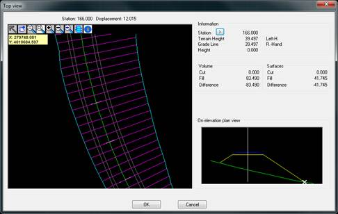
Check: Use this button to view the final state of our road in elevation plan view in a new window. For more detail see the section Check cross-sectionsin the section on Cross-sections.
Volumes report: This will display the volume report of the segment file. This option is described in more detail in Volumes section.
Draw: When this option is selected it will draw the cross-sections. For more detail see the section Draw cross-sections in the section on Cross-sections.
Proposed: This option is used to generate the final modified terrain of the road defined by the segment, and if roadbed layers exist, a modification associated with any of the existing roadbed layers can be generated. For more details, see the subsection Generate Proposed Terrain within the section Cross-Sections.
Top view: Use this button to visualize the top view of the complete road that we have defined with the working segment.
Sanitation Fill: If sanitation is defined in the section associated with the segment, this enables exporting the routing section as cross-sections file, which will appear as a black line in the drawing.