17.8. Executed Work |
This command operates exactly the same way as Quick Certification, only that instead of requesting a points file to verify the current state of the terrain, it requests a cross-section file.
The command first requests the segment from which to make the calculation, then the cross-section file of the current state of the terrain and finally the roadbed layer (if defined in the segment) for which the comparison will be made.
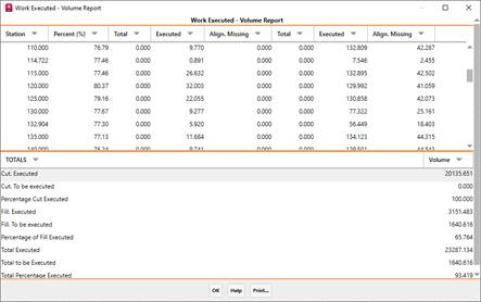
Last it displays the list and describes the characteristics with a description of each column:
Station: Station analyzed.
Theoretical Elevation: Elevation that should be reached when executing the works at the previous station.
Elevation: Elevation of the current terrain.
Executed: Area or volume executed according to the previous height.
Missing: Area or volume pending execution.
All these values are indicated for cut and fill. The end of the list displays the amount of square or cubic (volume) units executed and pending, along with the survey percentage completed.
|
|