10.4. Automatic Vertical Alignment |
This option will help us in the definition of a vertical alignment so that it fits a longitudinal profile according to previous parameters introduced by the user.
When executing the command initially it asks us to designate the profile drawn, then the following window will appear in which the necessary parameters for the calculation of the vertical alignment will be entered.
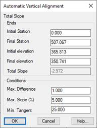
Initial Station: Initial Station from which the calculation will be performed.
Final Station: Final Station until which the calculation will be performed.
Initial Dimension: Initial dimension of the grade.
Final Height: Final height of the vertical alignemnt.
Max. Difference: We indicate the maximum difference in height between the terrain and the vertical alignment to be created.
Max. Slope (%) : We indicate the maximum / minimum slope of the vertical alignment to be created.
Min. Tangent: Parameter for the calculation of agreements. Minimum value of the tangent to adjust the agreements of the grade.
Once the dialog has been validated, the following window will appear with a report showing the calculations made according to the parameters previously entered.
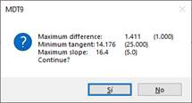
If we press affirmatively, the vertical alignment will be drawn automatically.
|
|