To properly display this page you need a browser with JavaScript support.
TcpGPS Windows
×
Menu Tab
Index Tab
Search Tab
Search Tab
Search Tab
5. File Management
5.12. Cartography
Previous page
Next page
(c) Company name, 2019
To properly display this page you need a browser with JavaScript support.
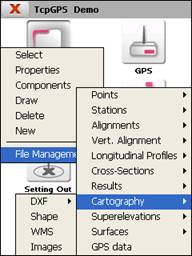
5.12. Cartography
In the different data acquisition and setting out options, the programme allows the use of cartography files with different formats as well as working in real time with the WMS services (Web Map Service) if there is an Internet connection.
The contents of:5.12. Cartography
DXF
Shape
WMS
Images